Severe Weather
Comprehensive Weather Briefing: Severe Thunderstorms and Coastal Hazards (August 21, 2026)
Executive Summary
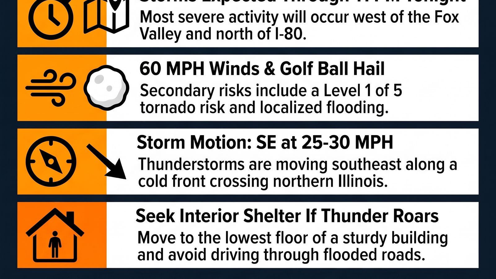
As of the afternoon of August 21, 2026, the National Weather Service has issued a series of critical alerts for portions of north-central and northeast Illinois, northwest Indiana, and southern Wisconsin. The primary short-term threat is a multi-modal severe weather event involving two distinct rounds of thunderstorms expected to persist through late evening. Key hazards include damaging wind gusts up to 60 mph, golf-ball-sized hail, and a low-end tornado risk. Concurrent with these atmospheric threats, significant marine and coastal hazards are developing on Lake Michigan, including life-threatening swimming conditions and small craft advisories. Furthermore, minor to moderate river flooding is ongoing in parts of Illinois and Indiana. A transition to quieter, high-pressure conditions is anticipated by early next week, with temperatures ranging from the mid-70s to low 80s.
I. Immediate Severe Weather Threats (August 21, 2026)
Severe Thunderstorm Watch #610
A formal watch is in effect until 10:00 PM CDT, covering a vast region across Illinois, Wisconsin, Iowa, and Indiana.
Illinois Counties: Includes 48 counties such as Cook, DuPage, Lake, Will, Kane, McHenry, DeKalb, Winnebago, Boone, and Lee.
Indiana Counties: Lake and Newton.
Wisconsin Counties: 9 counties including Dane, Rock, and Kenosha.
Primary Hazards: Scattered severe thunderstorms with damaging winds and large hail are the primary threats. An isolated tornado is also possible.
Regional Hazard Categorization
The National Weather Service has segmented the immediate threat into two primary zones:| Feature | Threat Area #1 (Primary) | Threat Area #2 (Secondary) || ------ | ------ | ------ || Location | Mainly west of a yellow dashed line (Central/Northern IL) | Eastern sections/Metro Chicago || Wind Hazard | Damaging Winds (up to 60 mph) | Gusty Winds || Hail Hazard | Damaging Hail (up to golf ball size) | Isolated severe storms possible || Additional Risks | Brief tornadoes cannot be ruled out | Torrential downpours, lightning strikes |
Specific Storm Case Study: Lee County, IL
A Severe Weather Statement was issued for northwestern Lee County following radar indications of a severe storm near Dixon moving southeast at 15 mph.
Identified Hazards: 60 mph wind gusts and quarter-sized hail.
Expected Impacts: Hail damage to vehicles; wind damage to roofs, siding, and trees.
Impacted Locations: Dixon, Nelson, and Woodland Shores.
II. Meteorological Analysis and Discussion
Current Storm Systems
The region is currently interacting with two atmospheric features:
Remnant Mesoscale Convective System (MCS): A decaying storm complex is tracking south across northern Illinois. While weakening, it continues to produce lightning and heavy rainfall.
Cold Front/Shortwave Trough: A more potent system is moving from the upper Midwest (western WI/central IA). Severe convection is expected to blossom along this boundary as it crosses into northern Illinois.
Atmospheric Instability and Dynamics
Technical analysis reveals significant potential for storm intensification:
MLCAPE Levels: Forecasted at 2,500 to 3,000 J/kg in western/northwestern areas.
Effective Shear: Marginal to fair (25 to 35 knots), supporting a "veering low-level shear profile" conducive to low-end tornado threats, particularly west of the Fox Valley and north of I-80.
Storm Motion: Systems are moving east-southeast at 20 to 30 mph.
Aviation Impacts
Aviation terminals (RFD, ORD, MDW) face two waves of activity:
Wave 1: Early-mid afternoon storms tracked along an outflow boundary, causing temporary northerly wind shifts.
Wave 2: Stronger storms expected late afternoon into evening. RFD stands the highest chance of direct impact from severe wind and hail.
III. Marine, Coastal, and Hydrological Hazards
Lake Michigan Coastal Hazards
A Beach Hazards Statement is in effect from Saturday morning through Sunday evening.
Conditions: High wave action (3 to 6 feet) and dangerous, life-threatening currents.
Locations: Porter, La Porte, Berrien, Muskegon, Ottawa, Allegan, and Van Buren counties.
Impacts: Strong currents can pull swimmers into deeper water; high waves may swamp piers and breakwalls.
Marine Advisories
Small Craft Advisory: Effective from Saturday morning through Sunday evening.
Conditions: Northwest winds of 15 to 25 knots with gusts up to 30 knots; waves reaching 3 to 6 feet.
Nearshore Hazard Risk: Level 2 of 5 for wind gusts up to 50 knots and half-dollar-sized hail tonight.
Hydrological Status (River Flooding)
River Location,Status,Details
Illinois River at Havana,Minor Flooding,Stage was 16.6 feet (Flood stage: 14.0 feet). Expected to crest at 16.7 feet.
Wabash River (Montezuma/Terre Haute),Moderate Flooding,Widespread minor to moderate flooding continuing through the weekend.
General Flash Flooding,Limited Risk,Heavy rainfall (1-2 inches) likely in low-lying and flood-prone areas.
IV. Five-Day Outlook (August 22 – August 26, 2026)
The severe threat is expected to exit the region shortly after midnight on August 21.
Saturday, Aug 22: Highs 75-80°F. Limited thunderstorm risk (20% chance). High swim risk at Porter County beaches.
Sunday, Aug 23: Highs 73-78°F. Sunny. Continued high swim risk for all Lake Michigan beaches.
Monday, Aug 24: Highs 72-77°F. Mostly sunny and quiet due to high pressure.
Tuesday, Aug 25: Highs 76-80°F. Mostly sunny with a limited thunderstorm risk (20-30%).
Wednesday, Aug 26: Highs 79-82°F. Slight chance of showers and thunderstorms (20-30%).
V. Recommended Precautionary Actions
The National Weather Service advises the following safety measures:
Severe Storms: Move to an interior room on the lowest floor of a building if a warning is issued.
Flooding: "Turn around, don't drown." Do not drive vehicles through flooded roadways; most flood deaths occur in vehicles.
Marine Safety: Inexperienced mariners should avoid navigating in hazardous conditions. Swimmers should remain out of the water and stay off piers and jetties during High Swim Risk periods.
Communication: Maintain multiple ways to receive weather warnings, as spotter activation may be required through this evening.
Executive Summary
As of the afternoon of August 21, 2026, the National Weather Service has issued a series of critical alerts for portions of north-central and northeast Illinois, northwest Indiana, and southern Wisconsin. The primary short-term threat is a multi-modal severe weather event involving two distinct rounds of thunderstorms expected to persist through late evening. Key hazards include damaging wind gusts up to 60 mph, golf-ball-sized hail, and a low-end tornado risk. Concurrent with these atmospheric threats, significant marine and coastal hazards are developing on Lake Michigan, including life-threatening swimming conditions and small craft advisories. Furthermore, minor to moderate river flooding is ongoing in parts of Illinois and Indiana. A transition to quieter, high-pressure conditions is anticipated by early next week, with temperatures ranging from the mid-70s to low 80s.
I. Immediate Severe Weather Threats (August 21, 2026)
Severe Thunderstorm Watch #610
A formal watch is in effect until 10:00 PM CDT, covering a vast region across Illinois, Wisconsin, Iowa, and Indiana.
Illinois Counties: Includes 48 counties such as Cook, DuPage, Lake, Will, Kane, McHenry, DeKalb, Winnebago, Boone, and Lee.
Indiana Counties: Lake and Newton.
Wisconsin Counties: 9 counties including Dane, Rock, and Kenosha.
Primary Hazards: Scattered severe thunderstorms with damaging winds and large hail are the primary threats. An isolated tornado is also possible.
Regional Hazard Categorization
The National Weather Service has segmented the immediate threat into two primary zones:| Feature | Threat Area #1 (Primary) | Threat Area #2 (Secondary) || ------ | ------ | ------ || Location | Mainly west of a yellow dashed line (Central/Northern IL) | Eastern sections/Metro Chicago || Wind Hazard | Damaging Winds (up to 60 mph) | Gusty Winds || Hail Hazard | Damaging Hail (up to golf ball size) | Isolated severe storms possible || Additional Risks | Brief tornadoes cannot be ruled out | Torrential downpours, lightning strikes |
Specific Storm Case Study: Lee County, IL
A Severe Weather Statement was issued for northwestern Lee County following radar indications of a severe storm near Dixon moving southeast at 15 mph.
Identified Hazards: 60 mph wind gusts and quarter-sized hail.
Expected Impacts: Hail damage to vehicles; wind damage to roofs, siding, and trees.
Impacted Locations: Dixon, Nelson, and Woodland Shores.
II. Meteorological Analysis and Discussion
Current Storm Systems
The region is currently interacting with two atmospheric features:
Remnant Mesoscale Convective System (MCS): A decaying storm complex is tracking south across northern Illinois. While weakening, it continues to produce lightning and heavy rainfall.
Cold Front/Shortwave Trough: A more potent system is moving from the upper Midwest (western WI/central IA). Severe convection is expected to blossom along this boundary as it crosses into northern Illinois.
Atmospheric Instability and Dynamics
Technical analysis reveals significant potential for storm intensification:
MLCAPE Levels: Forecasted at 2,500 to 3,000 J/kg in western/northwestern areas.
Effective Shear: Marginal to fair (25 to 35 knots), supporting a "veering low-level shear profile" conducive to low-end tornado threats, particularly west of the Fox Valley and north of I-80.
Storm Motion: Systems are moving east-southeast at 20 to 30 mph.
Aviation Impacts
Aviation terminals (RFD, ORD, MDW) face two waves of activity:
Wave 1: Early-mid afternoon storms tracked along an outflow boundary, causing temporary northerly wind shifts.
Wave 2: Stronger storms expected late afternoon into evening. RFD stands the highest chance of direct impact from severe wind and hail.
III. Marine, Coastal, and Hydrological Hazards
Lake Michigan Coastal Hazards
A Beach Hazards Statement is in effect from Saturday morning through Sunday evening.
Conditions: High wave action (3 to 6 feet) and dangerous, life-threatening currents.
Locations: Porter, La Porte, Berrien, Muskegon, Ottawa, Allegan, and Van Buren counties.
Impacts: Strong currents can pull swimmers into deeper water; high waves may swamp piers and breakwalls.
Marine Advisories
Small Craft Advisory: Effective from Saturday morning through Sunday evening.
Conditions: Northwest winds of 15 to 25 knots with gusts up to 30 knots; waves reaching 3 to 6 feet.
Nearshore Hazard Risk: Level 2 of 5 for wind gusts up to 50 knots and half-dollar-sized hail tonight.
Hydrological Status (River Flooding)
River Location,Status,Details
Illinois River at Havana,Minor Flooding,Stage was 16.6 feet (Flood stage: 14.0 feet). Expected to crest at 16.7 feet.
Wabash River (Montezuma/Terre Haute),Moderate Flooding,Widespread minor to moderate flooding continuing through the weekend.
General Flash Flooding,Limited Risk,Heavy rainfall (1-2 inches) likely in low-lying and flood-prone areas.
IV. Five-Day Outlook (August 22 – August 26, 2026)
The severe threat is expected to exit the region shortly after midnight on August 21.
Saturday, Aug 22: Highs 75-80°F. Limited thunderstorm risk (20% chance). High swim risk at Porter County beaches.
Sunday, Aug 23: Highs 73-78°F. Sunny. Continued high swim risk for all Lake Michigan beaches.
Monday, Aug 24: Highs 72-77°F. Mostly sunny and quiet due to high pressure.
Tuesday, Aug 25: Highs 76-80°F. Mostly sunny with a limited thunderstorm risk (20-30%).
Wednesday, Aug 26: Highs 79-82°F. Slight chance of showers and thunderstorms (20-30%).
V. Recommended Precautionary Actions
The National Weather Service advises the following safety measures:
Severe Storms: Move to an interior room on the lowest floor of a building if a warning is issued.
Flooding: "Turn around, don't drown." Do not drive vehicles through flooded roadways; most flood deaths occur in vehicles.
Marine Safety: Inexperienced mariners should avoid navigating in hazardous conditions. Swimmers should remain out of the water and stay off piers and jetties during High Swim Risk periods.
Communication: Maintain multiple ways to receive weather warnings, as spotter activation may be required through this evening.
Information
| Author | Simcha |
| Organization | Kol Simcha Productions |
| Website | - |

Copyright 2026 - Spreaker Inc. an iHeartMedia Company

Comments