December 18th Podcast: Focus- Late Week Impactful Winter Storm In Midwest Including Bitter Cold, Wind Storm and Snow especially December 23r
Dec 19, 2022 ·
42m 12s
12-18-23: Weather system on the way for the Midwest, an absolute nothing compared to what's going to be happening later on this week. We're going to skip just to what's...
show more
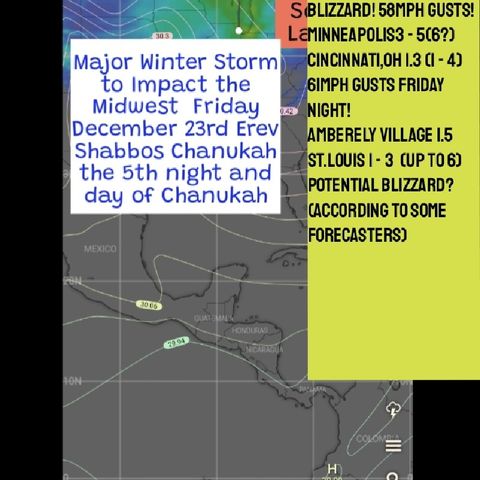
12-18-23: Weather system on the way for the Midwest, an absolute nothing compared to what's going to be happening later on this week. We're going to skip just to what's happening later on in the week. Two phenomenal weathermakers. Number one, a true powerhouse low pressure system developing. It's a Panhandle hook, a genuine the real thing, a true Panhandle hook. It's a low pressure system. It actually makes a hook. It takes that track, and it moves up into the Great Lakes colliding with copious amounts of Gulf moisture as the Panhandle hooks do. In the barometric pressure, reaching numbers that are, it's difficult to say without a racing heart for weather enthusiasts, the excitement is just so enormous. It's we're numbers which have dropped under 29.0 29.2 is the threshold of forecasting afoot. Some even say 29.3 We're already down 28.9 28.8 28.7. The computer models or European model, the most accurate model is taking this thing, the Great Lakes The thing is exploding, that it's explosive. And we're gonna read later on from the National Weather Service rate straight from the forecast discussion, nothing could say better than the way they wrote up the forecast discussion today. At the same time, we have another explosive airmass the exact opposite an area of high pressure coming out of Siberia coming straight into the US from into Montana 31.3 Approximately really strong high pressure, it's going to bring bitterly cold temperatures and one could just imagine the wind tunnel that's going to be produced in between these two systems. And that's where it's going to be snowing as well. Heavy snow which can be expected to form on the backside of the storm system of course, but you have just that in itself you would be dealing with a solid window 15 to 25 mile Barwon. But we have close to a record breaking high pressure airmass coming in from behind so we're talking about much stronger than normal, not just the normal 15 to 25 mile per hour wind. The European computer model is showing damaging wind gusts here in the Chicago area. This is the type of stuff that have been going on in the plains usually goes on in the plains and is confined to the plains doesn't usually go on here in the Chicago area. It has happened here in Chicago before. It's not an annual occurrence, but it's expected to happen this week and there's high confidence in this high impactful event. For those people that love snowstorms and love blizzard. This is really an ideal situation especially it's taking place over the holiday weekend. This is szabist conica. This shop is Friday afternoon. The wind speeds especially Friday and Friday night are just amazing. You look at the temperatures the temperatures don't look amazing to me. They don't look amazingly cold but the National Weather Service is talking about wind chill advisory criteria with windshields of 20 to 30 below zero. Now I thought that was windshield warning criteria. But they then say they might be issuing windshield warnings for windshields going beyond 30 below zero. You know you go into Nebraska you see very impressive cold in the Nebraska area. Nothing record breaking here in the Chicago area. From what I see. The forecast discussion from the National Weather Service doesn't exactly match up to what the actual forecasts are calling for. But those people that love snow should definitely be simpler this week. We have to say system coming in a minor system which might end actually as freezing drizzle for Monday night and Tuesday, or drizzle. And then we have the real system coming in might start late Wednesday night, but Friday is when the blizzard hits. There could very well be every single city, it's possible every city in the Midwest will get hit with some type of accumulating snow, when all is said and done at least an inch, something like that maybe just to happen in some of these cities, Cincinnati, Ohio, St. Louis, Missouri. Many, many cities, whereas the East Coast cities might be missing this. It looks like an all rain event for many of the East Coast cities. One would ordinarily expect a low pressure system, the 28th to be developing on the East Coast. Not something to be forming here in the Midwest, but we have it here in the Midwest. That's what's expected to happen. And the confidence is increasing. This is only five days away right now. We are a mere five days away. The origines of the system right now are is hanging out over in the Alaska area. A lot could certainly change but it is a mere five days away.
The first blizzard in 42 years is a possibility in the St. Louis area. This upcoming week, guidance has changed significantly over the past 24 hours and in our peers like the main moisture, the main precipitation over in the St. Louis area will be falling after will be falling behind the low pressure system instead of ahead. This will create a high snow to water ratio, greatly increasing the amount of snowfall accumulation. Oh my gosh. More significantly. The wind forecast is just unbelievable. This goes for oh, by the way for all the Midwest cities. This includes St. Louis. I would imagine many more cities, the cities that I looked into or Chicago, Milwaukee, Cincinnati and St. Louis. All of those cities have very intense wind speeds. For example, Cincinnati might be the most intense, with damaging wind gusts damaging wind gusts expected Friday night in Cincinnati, with significant snow in Cincinnati as well. When we say significant snow, it's not really as significant as the other cities but when you combine about probably approximately two to four inches at this point, things are always changing however, and they've been going up but two to four inches the main system is missing Cincinnati. And much of the system might be missing St. Louis as well. Nonetheless, the font itself, just the front in the amount of precipitation just falling along the front and right behind the front. That itself will be squeezing out a few inches of snow perhaps several inches of snow in St. Louis looks like they'll be getting a little bit more than just several. So probably a winter storm watch will likely be issued for the St. Louis area. Chicago is in a whole new level over here in a certain way because of the high snowfall totals which are expected to reach Chicago and Milwaukee as well.
The winds will be the same in Chicago, very strong winds. sustained winds might even be stronger in Chicago, but the wind gusts, you know, very high in Cincinnati. What we have going on right now is we have a an extremely strong high pressure system coming out of Siberia. This high pressure is 1050 MB to translate that into the regular American barometric pressure is I don't know, but the low pressure, the high pressure things that I've seen. So 31.3 moving into Montana, the core of the cold, it's Nebraska, Johnston, Nebraska, Johnstown, Nebraska, temperatures hit 24 below zero. This is Friday morning with an afternoon high of 18 below zero. This is polar vortex material. You know, for us Chicagoans when you think back and remember what it was like. When we received the polar vortex. It's very similar stuff. When you go back to that date on December 23. You might see that the high temperature was higher than 18. Below for Johnstown, Nebraska. But that's because it will be occurring a little bit after midnight. Even so the highs will still be below zero. Now, the question is, what's going to happen afterwards. Now if you notice, up until now, actually, unbelievably, temperatures have been forecasted to be colder in St. Louis, than Chicago. Now I'm going to explain why. The reason is because As that arctic air moves in, so once a storm system develops, it stalls the arctic air once the arctic air stalls, then it starts to moderate. So the goal in terms of that arctic air to get it down as quickly as possible. That's the arctic air is goal that has a goal.
But once it reaches, it gets closer to the golf, it collides with significantly warm and more moist air and add to it. Once it gets significant enough a storm system develops and that's what's going to be happening. And the cold air reaches its intensity in Nebraska. Before that arctic air stalls. There are questions exactly where will St. Louis be in proportion to the stalling arctic air. So these snowfall amounts have to be worked out for St. Louis, Missouri. But you know, one thing no matter what city you live in, in the Midwest, you're going to be seeing very powerful winds. Winds capable of producing power outages. These are when we when the National Weather Service issues a severe thunderstorm warning warnings are issued when you have wind gusts of 58 miles per hour or higher. Here we don't have any thunderstorms. But the wind gusts may also exceed 58 miles per hour or higher. Wind gusts may hit 60 or 61 miles per hour. So there could be power outages. Another thing that could be expected from what I've seen, regardless as to where the storm system is, you know, everyone can be paying attention to the exact track of the snow, the exact track of the storm to figure out where you are in relation to the bull's eye of the storm. Will you be in the six to 12 inch Bullseye that usually develops in the Midwest, will you be in a three to six inch will you be in the one to three inch but I think that one to three inch bull's eye. It's not a bull's eye anymore. But that 123 inch area might be a lot might be very widespread. Not just because you also have the snow associated with the front and that front is moving through every city. Every city will be affected by that front and any area which is affected by the front we'll be seeing snow so every single city will see snow that that's a that's what I saw. Every single city will be seeing. You know we're talking at least about an intense snow shower. The question is how much snow so I don't know. One would think there would have to be some type of snowfall accumulation. And I think the one to
show less
The first blizzard in 42 years is a possibility in the St. Louis area. This upcoming week, guidance has changed significantly over the past 24 hours and in our peers like the main moisture, the main precipitation over in the St. Louis area will be falling after will be falling behind the low pressure system instead of ahead. This will create a high snow to water ratio, greatly increasing the amount of snowfall accumulation. Oh my gosh. More significantly. The wind forecast is just unbelievable. This goes for oh, by the way for all the Midwest cities. This includes St. Louis. I would imagine many more cities, the cities that I looked into or Chicago, Milwaukee, Cincinnati and St. Louis. All of those cities have very intense wind speeds. For example, Cincinnati might be the most intense, with damaging wind gusts damaging wind gusts expected Friday night in Cincinnati, with significant snow in Cincinnati as well. When we say significant snow, it's not really as significant as the other cities but when you combine about probably approximately two to four inches at this point, things are always changing however, and they've been going up but two to four inches the main system is missing Cincinnati. And much of the system might be missing St. Louis as well. Nonetheless, the font itself, just the front in the amount of precipitation just falling along the front and right behind the front. That itself will be squeezing out a few inches of snow perhaps several inches of snow in St. Louis looks like they'll be getting a little bit more than just several. So probably a winter storm watch will likely be issued for the St. Louis area. Chicago is in a whole new level over here in a certain way because of the high snowfall totals which are expected to reach Chicago and Milwaukee as well.
The winds will be the same in Chicago, very strong winds. sustained winds might even be stronger in Chicago, but the wind gusts, you know, very high in Cincinnati. What we have going on right now is we have a an extremely strong high pressure system coming out of Siberia. This high pressure is 1050 MB to translate that into the regular American barometric pressure is I don't know, but the low pressure, the high pressure things that I've seen. So 31.3 moving into Montana, the core of the cold, it's Nebraska, Johnston, Nebraska, Johnstown, Nebraska, temperatures hit 24 below zero. This is Friday morning with an afternoon high of 18 below zero. This is polar vortex material. You know, for us Chicagoans when you think back and remember what it was like. When we received the polar vortex. It's very similar stuff. When you go back to that date on December 23. You might see that the high temperature was higher than 18. Below for Johnstown, Nebraska. But that's because it will be occurring a little bit after midnight. Even so the highs will still be below zero. Now, the question is, what's going to happen afterwards. Now if you notice, up until now, actually, unbelievably, temperatures have been forecasted to be colder in St. Louis, than Chicago. Now I'm going to explain why. The reason is because As that arctic air moves in, so once a storm system develops, it stalls the arctic air once the arctic air stalls, then it starts to moderate. So the goal in terms of that arctic air to get it down as quickly as possible. That's the arctic air is goal that has a goal.
But once it reaches, it gets closer to the golf, it collides with significantly warm and more moist air and add to it. Once it gets significant enough a storm system develops and that's what's going to be happening. And the cold air reaches its intensity in Nebraska. Before that arctic air stalls. There are questions exactly where will St. Louis be in proportion to the stalling arctic air. So these snowfall amounts have to be worked out for St. Louis, Missouri. But you know, one thing no matter what city you live in, in the Midwest, you're going to be seeing very powerful winds. Winds capable of producing power outages. These are when we when the National Weather Service issues a severe thunderstorm warning warnings are issued when you have wind gusts of 58 miles per hour or higher. Here we don't have any thunderstorms. But the wind gusts may also exceed 58 miles per hour or higher. Wind gusts may hit 60 or 61 miles per hour. So there could be power outages. Another thing that could be expected from what I've seen, regardless as to where the storm system is, you know, everyone can be paying attention to the exact track of the snow, the exact track of the storm to figure out where you are in relation to the bull's eye of the storm. Will you be in the six to 12 inch Bullseye that usually develops in the Midwest, will you be in a three to six inch will you be in the one to three inch but I think that one to three inch bull's eye. It's not a bull's eye anymore. But that 123 inch area might be a lot might be very widespread. Not just because you also have the snow associated with the front and that front is moving through every city. Every city will be affected by that front and any area which is affected by the front we'll be seeing snow so every single city will see snow that that's a that's what I saw. Every single city will be seeing. You know we're talking at least about an intense snow shower. The question is how much snow so I don't know. One would think there would have to be some type of snowfall accumulation. And I think the one to
Information
| Author | Simcha Lefton |
| Website | - |
| Tags |
Copyright 2024 - Spreaker Inc. an iHeartMedia Company
